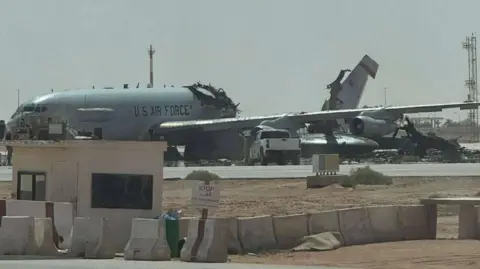
Verified pictures show that a US command and control aircraft, specifically an E-3 Sentry, has been heavily damaged at an air base in Saudi Arabia.
The photographs were initially shared on a Facebook page focusing on US military news and depict the aircraft as being split in two.
Confirmation of the damage has been made, revealing that it occurred at the Prince Sultan air base, located approximately 100km southeast of Riyadh. Observations such as pylons and storage units visible in the images have been cross-referenced with satellite imagery.
At this time, US Central Command has not issued a public statement regarding the incident, although inquiries are underway by the BBC.
On Friday, a US official reported to Reuters that 12 US personnel sustained injuries, with two in serious condition, due to an Iranian military attack targeting the air base. Additional reports indicated that at least two US refueling aircraft were also damaged in the assault.
Iranian state media reported that an attack drone, specifically a Shahed drone, struck the E-3 aircraft. Meanwhile, BBC Verify has noted that satellite images taken on March 11 captured the E-3 at the same location, though it's unclear if they refer to the same aircraft.
Following analysis of the visible tail number on the damaged aircraft, flight-tracking data revealed it was operational near the airbase on March 18.
Recent satellite images taken on Friday displayed signs of fire at the air base apron, about 1,600m east of the E-3, but further clarification on whether this was related to the assault causing the aircraft's damage is still pending.
The Boeing E-3 AWACS, which stands for Airborne Warning and Control System, is derived from the Boeing 707 airliner and is outfitted with a distinctive radar dish at the rear. This radar is crucial for monitoring and tracking potential threats at considerable distances, thus, supporting early warnings during combat operations.
Having entered service in 1977, the E-3 is expected to remain in service with the USAF until 2035, providing vital data to air operations commanders for maintaining control over aerial engagements.